[September 2, 2017 – October 20, 2017] Drift Scan
The technique of “Drift Scan” is just keeping the antenna pointed in one fixed direction, while the sky passes overhead as the Earth turns. Rather than track a particular object, the sky is passively scanned, as the sky “drifts” across. The technique of “Drift Scan” is just keeping the antenna pointed in one fixed direction, while the sky passes overhead as the Earth turns. Rather than track a particular object, the sky is passively scanned, as the sky “drifts” across.
Current Drift Scan with antenna set to an elevation 2.5° north of zenith (92.5° from south horizon), azimuth along meridian. As the Earth rotates, scans a complete strip of sky at 41° Declination. Measurements: Current Drift Scan with antenna set to an elevation 2.5° north of zenith (92.5° from south horizon), azimuth along meridian. As the Earth rotates, scans a complete strip of sky at 41° Declination. Measurements:
-
- Total power measurement @ 1428 MHz, beam size 2°
- Neutral hydrogen spectral line measurement
- Search for radio source Cygnus A (19h 58m RA, 41° Dec.) and the Milky Way galactic plane. (Click image for detail.)
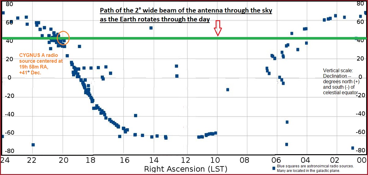
This is a chart of the sky, showing where the radio telescope beam currently aims, as the Earth rotates once completely. The radio telescope latitude is 38.5 degrees. If the dish were aimed straight up at the zenith, the dish would scan the sky at a celestial latitude (called Declination) of 38. 5 degrees. The dish is pointed 2.5 degrees north of zenith, and so the sky is scanned across at 41 degrees celestial latitude, or Declination (the green line).
At the frequency of neutral hydrogen (1428 MHz) the dish antenna can “see” the sky, can receive signals, with a width of about 2 degrees (the thickness of the green line).
The blue squares are positions of the brighter radio sources at 1428 MHz, according to radio astronomy catalogs. Many of those are in the plane of our galaxy, the Milky Way. The plane of our galaxy is inclined at an angle to our equator. Those radio sources projected on to this squared off map therefore appear like a sinusoidal arc. Our current target of interest is the radio source Cygnus A, in the constellation Cygnus. Its celestial coordinates are 19h 58 min Right Ascension, 41 degrees North Declination.

60-foot radio telescope dish antenna set to an elevation 2.5° north of zenith. 60-foot radio telescope dish antenna set to an elevation 2.5° north of zenith.